.svg "Logo (1)")
-1.svg)

An inside look at how Central Coast Council is working with the NSW Government and the community on progressing a long term solution for the erosion problem at Wamberal Beach.
The survey link is available at the end of the information package.
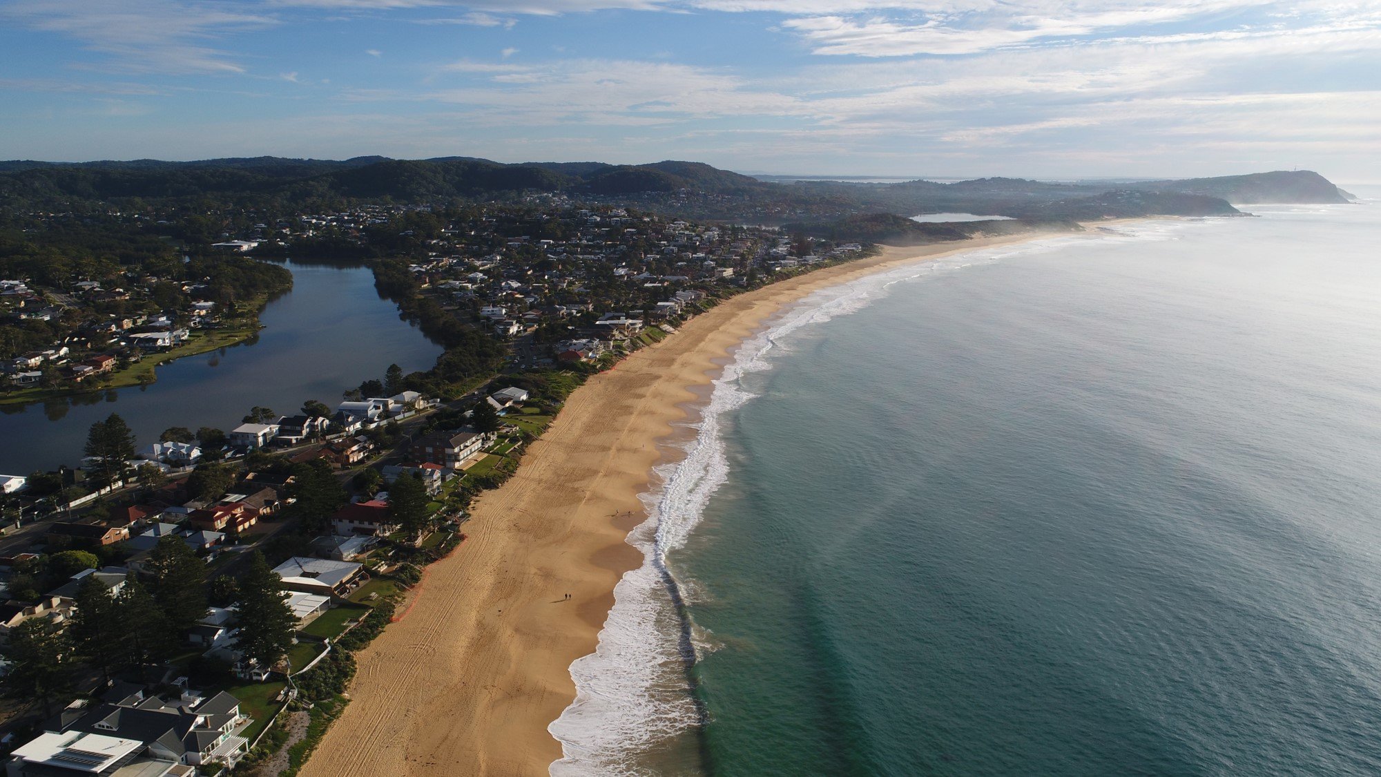
Coastal erosion is a natural process that occurs when ocean storm activity impacts a beach. This becomes a problem when coastal infrastructure and public safety are threatened. Coastal erosion is a complex problem faced by many coastal communities and governments across Australia.
New South Wales has several locations that are experiencing significant erosion problems. Wamberal Beach is one of the most exposed beaches in this state, having suffered severe erosion impacts on many occasions. Resolving complex erosion problems, like that at Wamberal Beach, requires big picture thinking, collaborative partnerships and innovate solutions.
A sustainable long-term solution would both reduce the risk to coastal infrastructure and public safety from erosion, and deliver improved recreational amenity and public access for the community.
Finding a solution that strikes the right balance is not straight forward. Technical, economic, environmental, social and legislative challenges must be first worked through. This requires all levels of government and the community to work together.
A coastal engineering and economics investigation for Wamberal Beach is currently underway. Experts will provide options to more sustainably manage the erosion threat over the longer term. This will deliver on commitments made through the Gosford Beaches Coastal Zone Management Plan.
Also underway is the NSW Government’s Wamberal Seawall Advisory Taskforce, which has been established to assist Council and the community work toward a solution for managing the coastal erosion problem at Wamberal Beach.
Good coastal management outcomes can only be achieved through active involvement and support from coastal communities. Council understands that the Wamberal and broader Central Coast community is diverse and has a high level of interest in this project. Council will be engaging with locals and the broader community, as we work through this problem together.
Beaches are dynamic natural systems that are exposed to never ending changes. Human use of the coastal environment also changes through time.
Here is a snap shot of how Wamberal-Terrigal Beach has changed over the years.
Central Coast Council acknowledges that the Wamberal – Terrigal Beach is part of the traditional country of the Darkinjung and Guringai (Kuringgai) people. We pay our respects to Elders past, present and emerging.
Wamberal is an Aboriginal word meaning 'where the sea breaks' (Bennet, 1969) (Photo by: J. Donaldson)
Terrigal was first settled in 1826.
In 1833, the Wamberal beachside area was granted as freehold land. This was subdivided in 1886 as part of the ‘Gosford Model Farms’. The dynamic nature of the coastline was not recognised at this time.
‘Gosford Model Farms’ Plan DP 1976 (main) and advertisement (insert), showing Wamberal Beachfront subdivision, circa 1886 (Sources: New South Wales Land and Property Information; Central Coast Library Services)
Tourism became important at Terrigal late in the 1800’s and early 1900’s. The Terrigal Surf Life Saving Club was formed in 1924. You can see here the prominent erosion escarpment in the densely vegetated Wamberal Beach dunes.
Top Left: Early view of Terrigal looking north to Wamberal, 1920 (Source: Central Coast Library Collection); Top Right: Ocean and Lakes Terrigal, circa 1910 (Source: State Library of New South Wales); Bottom Right: Terrigal Wamberal Beach circa 1930s, by Amy Ringham; (Source: Central Coast Library Collection); Bottom Left: Children in the Surf at Terrigal, circa 1900-1930; (Source: State Library of New South Wales); Inset middle: Terrigal Wamberal and Avoca at a glance 1924 (Source: Central Coast Library Collection); Inset right: Terriwamba Estate map, circa 1925-29 (Source: Central Coast Library Collection)
Beachside development towards the south end of Wamberal can be seen by the early 1940’s (vicinity of Pacific Street). A seawall was constructed at Terrigal by this time too. The Wamberal Surf Life Saving Club formed in 1950.
Foreshore development extended along much of the beach, between Terrigal and Wamberal Lagoons by the late-1950’s to mid-1960’s.
The 1960’s saw a period of significant sand build up on the beach and dunes. Development expanded on the west side of Ocean View Drive, along the edges of Terrigal Lagoon.
Left: Wamberal-Terrigal Beach, November 1941 (Source: NSW Land and Property Information); Right: Wamberal-Terrigal Beach, May 1964 (Source: NSW Land and Property Information); Inset top: Girls Leadership Camp at Wamberal, 1940, by N Herfort; (Source: State Library of New South Wales); Inset bottom: Terrigal Lagoon & Wamberal Beach, circa 1955-1962; (Source: Central Coast Library Collection)
The Central Coast was battered by a stormy period in the 1970’s. Land was lost to erosion from severe coastal storms in 1974 and 1978.
The major storms of May-June 1974 threatened all beachfront properties at Wamberal and damaged one house. The State Emergency Service and the Australian Army placed rocks, sandbags and other materials in front of the erosion scarp. Ad hoc protection works (rock rubble, corrugated iron, concrete walls) were also placed on the beach.
In June 1978, land was again lost to the ocean from major storms that occurred. Erosion resulted in two neighbouring houses being washed away by heavy seas.
Much of the ad hoc protection works remains on the beach today.
Left: Wamberal beach erosion showing house under threat and wreckage of another, June 1978, photo by Gwen Dundon (Source: Central Coast Library Collection); Right top: “Sea Takes Over” (Source: Central Coast Express, 21 June 1978); Right bottom: Wamberal-Terrigal Beach, June 1978 (Source: NSW Land and Property Information)
The early 1990’s saw another period of significant sand build up on the beach and dunes. The sandstone block wall was built at Terrigal in 1999. The beach and dunes were mostly steady during the 2000’s also.
Large storms impacted Wamberal-Terrigal Beach during in 1995 and 2007.
To address the ongoing erosion threat, a seawall and sand nourishment protection solution was recommended in 1995 (WBM). This plan was designed in 1998 (WRL) and assessed through an Environmental Impact Statement (EIS) in 2003 (MHL). Council adopted the EIS protection plan in 2004, however funding could not be secured. For this reason, the approved long-term solution did not progress.
Left: Wamberal-Terrigal Beach, May 1990 (Source: NSW Land and Property Information); Right: Wamberal-Terrigal Beach, March 2006 (Source: NSW Land and Property Information); Inset: Historical Wamberal Beach profiles, showing wide and healthily beach/dune conditions in 1990 and 2006, compared with severely eroded beach/dune conditions in 1974 and 2020 (Source: NSW Government)
Beachside development was again threatened by a destructive erosion event in June 2016. This was caused by a major coastal storm with an unusual wave direction and king tides. In addition to the erosion impacts, waves washed through Terrigal Lagoon entrance, causing flooding and damage to lakeside properties.
Rock, building rubble and other ad hoc protection materials from the 1970’s was exposed in the Wamberal dunes and on the beach. Some houses were left hanging on the edge of the erosion cliff face.
Several large storms impacted Wamberal-Terrigal Beach in 2020. The most destructive erosion event occurred from a major storm in mid-July which impacted numerous properties. Approximately 54 residents were evacuated for their personal safety. Hazardous rubble and debris were strewn across the beach.
A rapid and coordinated erosion emergency response at Wamberal saw the placement of 4,400 tonnes of rock by Council, under emergency orders by the NSW Government appointed Local Emergency Operations Controller. Guided by expert coastal engineers, the emergency rock works ensured that coastal infrastructure was not further damaged by wave action throughout the emergency event. These rock works are not a permanent solution to the erosion issue.
Left: Wamberal-Terrigal Beach, November 2016 (Source: Nearmap); Right: Wamberal-Terrigal Beach, September 2020 (Source: Nearmap); Inset top: Wamberal erosion impacts, July 2020 East Coast Low (Source: Central Coast Council); Inset bottom: Wamberal erosion impacts, June 2016 East Coast Low (Source: Central Coast Council)
Wamberal-Terrigal Beach naturally moves both back and forth. It is a dynamic coastal system. Wamberal Beach has been long recognised as a ‘hot spot’ for erosion, with several major storms threatening coastal infrastructure over a 50 year period. Rocks and rubble have been placed along the back of the beach by various governments and individuals during this time. These will inevitably be covered up again at some point, as the beach naturally recovers over time, and then re-exposed in the event of another destructive coastal storm like that experienced in 1974, 1978, 2016 and 2020. In the absence of a long-term solution the risk of further erosion impacts will remain.
Many reports have investigated the coastal erosion problem at Wamberal-Terrigal Beach. These reports have all found that:
What is at risk from erosion?
Beachside infrastructure is at risk from coastal erosion now. Coastal risks will increase with climate change due to rising sea levels. Public roads and community infrastructure will be exposed to erosion impacts in the future.
Under present day conditions, erosion modelling shows that 73 beachfront lots are at risk from erosion impacts, including 61 residential buildings. By 2050, there is the potential for Ocean View Drive to be affected by coastal erosion. By 2100, an increasing number of lots/buildings, increasing lengths of road and the Wamberal Surf Life Saving Club may be at risk from coastal erosion (Worley Parsons, 2014; 2015). More recent erosion modelling by the NSW Government shows a broadly consistent degree of coastal risk.
Left: Wamberal Beach erosion forecast modelling, for the present day and 2050 timeframe (Source: NSW Office of Environment & Heritage, 2016); Right: Erosion hazard mapping 2034, showing the a potential range impacts for Wamberal Beach over the 15-20 year period (Source: Kinsella et al, 2017; Journal of Marine Sciences)
The NSW Government has laws in place that guide how the NSW coastline is managed.
The Gosford Beaches CZMP was prepared in line the NSW Government legislation, and in consultation with the Central Coast community. The CZMP was adopted by Council and certified by the Minister for the Environment in May 2017. The CZMP remains in force and is consistent with the new Coastal Management Act 2016.
The CZMP identified a number of key management actions for Wamberal Beach, including:
Sand nourishment coupled with a terminal seawall (Action: TW 15) is the preferred long-term solution for Wamberal Beach in the CZMP. However, the CZMP does not provide for the construction of a seawall. Indeed, the solution is complex - requiring input and agreement from a number of parties.
Background: Coastal Processes Brochure, Gosford Beaches CZMP (Source: WorleyParsons, 2017); Right: Gosford Beaches Coastal Zone Management Plan (Source: WorleyParsons, 2017); Inset: Open Coast and Broken Bay Beaches Coastal Hazard Definition Study (Source: WorleyParsons, 2014)
Through the development of the Gosford Beaches CZMP all viable long-term solutions were reviewed in consultation with the community at the time. Terminal protection and sand nourishment were identified as the preferred solution and were included in the certified final version of the CZMP.
Options for progressing the preferred long-term solution for Wamberal Beach are now being investigated by experts in coastal engineering.
Coastal engineering investigation
Council is currently working with the coastal engineering and economics experts to complete coastal investigations, concept designs, and related technical assessments. The integrated project team includes consultants from Manly Hydraulics Laboratory, Water Research Laboratory (University of NSW) and Balmoral Group Australia.
This work being completed includes:
This coastal engineering study will ensure Council completes the Wamberal based actions in the CZMP. It will also allow Council and the community to make an informed decision on the best combination of protection and sand nourishment options for Wamberal Beach.
Information collected during the consultation for this project will inform decision-making on this project and its findings will be made public.
Wamberal post July 2020 storm (onshore and offshore) coastal monitoring (Source: Water Research Laboratory, 2020)
The Wamberal Seawall Advisory Taskforce was established by the NSW Minister for Local Government in response to the erosion emergency in 2020. It includes representatives from the NSW Government and Central Coast Council. The Advisory Taskforce has been meeting monthly since August 2020.
The Advisory Taskforce is providing technical advice to support the delivery of a long-term solution for Wamberal Beach.
You can view the background to the Taskforce and meeting minutes on our website.
By completing the Wamberal Beach values and uses survey you’ll be letting us know what’s important to you and why. This information will assist Council in the decision-making process.


2 Hely Street,
Wyong NSW 2259
P. 02 4306 7900